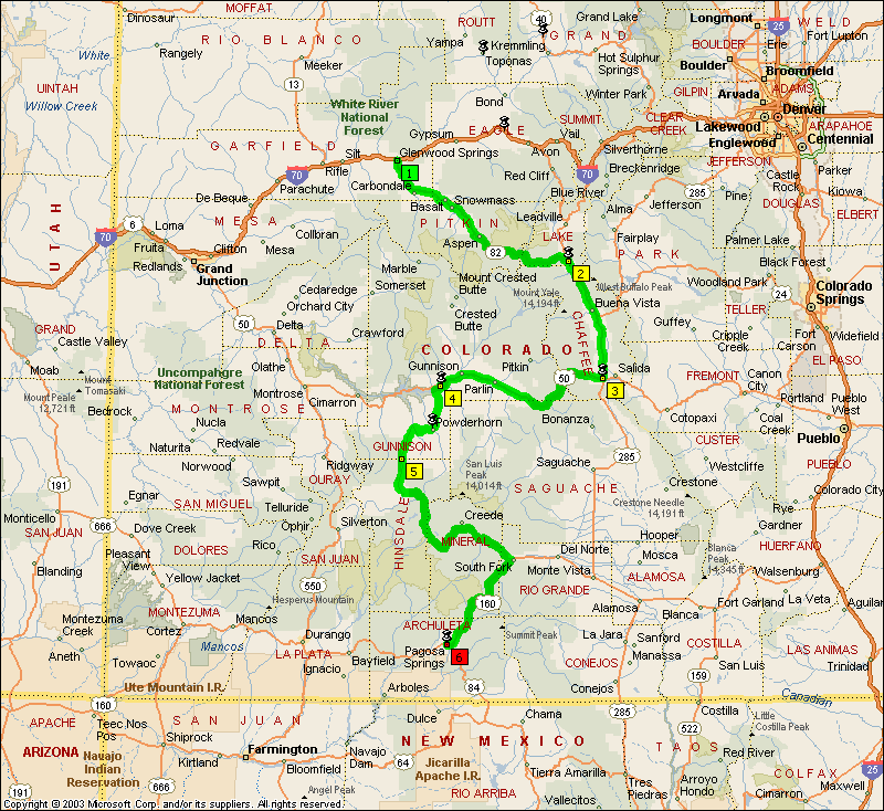
October 2
|
|
I was up around 7:30. Frank already had coffee on in a cool, insulated stainless steel French press. Got to have me one of those! We snacked for breakfast and stood in the kitchen, chatting, until about 9, when I decided that it was time to hit the road. By 9:45 I was headed down the driveway, headed towards Aspen, Independence Pass, and a little town on the other side of the mountain called Buena Vista (BV by the locals), were I was supposed to meet Eric at noon for lunch.
|
Aspen, looking up the ski slope. |
This was the third time I had been over Independence Pass, and it is one of my all-time favorite roads. Being leaf season, there was a fair amount of traffic, but I didn’t really care. I wasn’t trying to go fast, I was just enjoying the scenery. That was not true of everybody, however. As I descended the far side, a Toyota 4-Runner blasted past me, and he was passing traffic in areas that I wouldn’t have tried even on the bike! He wanted to get somewhere NOW. |
|
|
|
|
|
|
|
|
|
|
|
|
I was about 40 minutes late getting into BV, and found Eric sitting at a gas station, waiting patiently. We had lunch at a place called Jan’s; I had an OK hamburger, but Eric said that his rueben sandwich was excellent.
Between the turnoff from Independence Pass and US 50, we passed 5 peaks over 14,000 feet.
South of BV we turned west on US 50, which was a very nice ride through a big valley, nothing spectacular, but still a lot of fun, especially as we approached Gunnison and the valley closed in on the road, forming a canyon and tightening up the curves. Just before Gunnison we turned south on 149, and discovered another road for the “Died And Gone To Heaven” list. Big sweepers mixed in with tight technical sections, beautiful forests and rivers, scattered clumps of mule deer, and three passes higher than 10,000 feet. What more could you ask for? The second pass, Spring Creek, even had a little snow up top, the only snow we saw the whole trip. There were plenty of 20 MPH S turns, and one 15 MPH 180. The few towns that were on this road had towering trees (cottonwoods, maybe?) lining the streets, blazing with the reds, oranges, and yellows of autumn. Our third big pass, Wolf Creek, had recently suffered a landslide, and there was a good stretch of road that was torn up, with house-sized boulders scattered around like pebbles. There was also a Colorado State Trooper at the top of the pass, but the detector saw him a long way off. We had a LOT of fun on this road.
|
|
|
|
|
|
I was really surprised that this beautiful road, in the height of leaf season, was practically abandoned. There was no traffic to speak of.
It was close to dark when we got to Pagosa Springs, which was a smaller town than we expected. Barb had told us to soak in the hot springs by the river if we had a chance. There were two resorts on the river that catered to “soakers”. We took a look at the Best Western across the street from the springs, but it looked like it was under renovation, and we couldn’t even find the office. The resorts on the river were full, as were the places they recommended for overflow. We cruised back and forth through town a few times, and finally settled on an older mom-and-pop hotel that catered to hunters. $79 bought a basic room, no breakfast. But they did have a laundry, which we needed, and there was a Chinese restaurant across the street that desk clerk worked a second job at. He not only worked there, he also ate there, and we figured that was a good sign. It turned out to be clean and the food was quite good.
We didn’t bother to go back to the hot springs after dinner, as we were ready for bed.
371 miles for the day.