September 21
We got rolling about 9
AM after a good hot breakfast at the hotel.
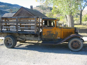
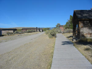
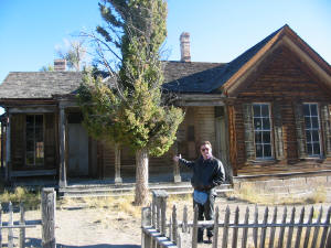
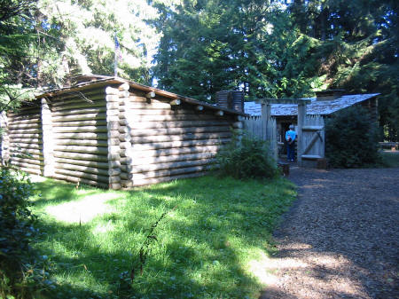
Our first stop was Bannack, a state park that was the first capital of
the Montana territory, and is now preserved as a ghost town.
It was founded in the mid 1800s and was a mining town.
Very interesting, worth the side trip.
The valley below the road leading into Bannack was eaten up with mule
deer. As we came out, I topped a
hill to find two antelope in the middle of the road.
I idled up to them and they moved off into a field to the right, not all
that afraid, but wary. Then we
headed north on 278. I decided not
to try Lehmi pass, since the road was unpaved and I could not get current road
conditions. Rode to Big Hole
National Battlefield, where a bloody battle was fought between the US Calvary
and the Nez Perce. The countryside
was rolling hills, grassy in the valleys and wooded on the tops.
Beautiful. Coming through
one town we passed a group of bikes out for a Sunday drive, probably 70 bikes in
formation. As we came up 93 through
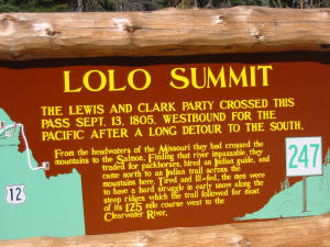
Hamilton, the country wasn't as pretty, but then we came to...US12.
The road I had been waiting on for so long. What a great road, up over
the Lolo pass. The road follows the
Lochsa-Clearwater canyon, and is a little south of the Lolo Trail, which is an
old Nez Perce trail that LC took. The
canyon back then was too narrow for horses, and the river was un-navigable.
The canyon is so tight that US12 wasn’t even completed until 1962.
One of the privates on the LC expedition had said that these mountains
were “the most terrible mountains I ever beheld.”
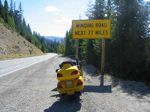
Sound like a recipe for great roads?
How about 77 miles of winding roads up in the forest along the river,
then down into the rolling hills and grasslands of the Palouse?!
We ran 80 and 90 coming down the mountain.
Eric said that this was the best road he had ever ridden. We stopped for a break and talked to two Harley riders out
for a weekend trip from Spokane...nice guys.
No windshields, one with no helmet, and there were lots of bugs out!
Tougher than me! We were
going to stop in Lewiston, but decided to go on to Walla Walla.
Ended up with 495 miles on for the day, took a room at a Holiday Inn
Express. Had a great micro-brew at
dinner call Obsidian, made in Bend, OR, and I looked for it the rest of the
trip, but never found it again.
|
|
|
|
|
|
|
|
September 22
|
|
Up to a nice
breakfast, then headed out of Walla Walla.
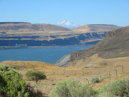
Ran Hwy 12 to the Columbia River, then took 730 to Umatilla, then across
to the
Washington side on Hwy 14. It
appeared that this would be the better route, scenery-wise, and we were not
disappointed. The landscape
was rolling, arid hills with the river on the left, many times no more than a
lake, due to the dams. I found
myself (as on the lower Missouri) wondering what
the area had looked like those many years ago when LC had traveled here.
We entered the Columbia River Scenic Gorge Area, and huge cliffs
surrounded us, with views across the river dominated by Mt. Hood. Then…onions. The
air smelled like onions. Odd, I
thought. About 10 miles up, I
discovered why…I caught up to a semi-truck with a huge load of onions!
Amazing that I could smell him so far back. Later, a hay truck met us, and as we passed him we were
caught up in a swirl of hay…the road was littered with hay for miles behind
him. I bet the lost half of his
load by the time he stopped! |
As we entered
Portland, we pulled off for gas, and Eric recognized the exit…he had friends
that had a business just a couple of blocks away! So we took a few minutes and visited with Patty and her
staff. Then up I205 for a hot and
busy ride loaded with speed cops. At
Longview we were able to get back to our beloved 2 lanes, on Hwy 4, skirting the
north bank of the Columbia. The
landscape alternated between lush fields and hills with dense growth of ferns,
the first I remember seeing. As we
approached the Pacific, the boat traffic picked up considerably, a lot of it
being salmon boats, drift fishing, just like Eric does back in Alaska.
They really like bowpickers here. Then
we rounded a corner and BAM there was the mouth of the Columbia, the Astoria
Bridge spanning over to Oregon, and a wall of fog hanging just off the coast.
LC had crappy weather here. High
winds, waves, cold and rain. We had
mid 70's, clear skies, light winds, and smooth water. How lucky could we get?
We crossed the bridge, and I kept looking out over the bar and the
weather standing off the coast…I had forgotten how that happened a lot in the
west. We breezed
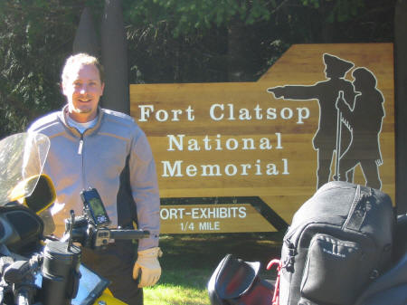
through Astoria, and on to Fort Clatsop. The
end of the line, my goal complete. This
is where LC had spent the winter of 1805, cold, wet, homesick, and miserable.
They had 12 days without rain that winter.
I gave thanks again for the wonderful weather we were having!
We arrived at the park about an hour and a half before closing, just
enough time to run through the small museum and walk down to the reconstructed
fort. I had expected it to be on
the riverbank, and was surprised to find in on a bluff in the forest,
surrounded by huge trees. We left
as the park closed, then headed on to Newport.
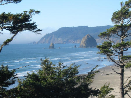
The coast was stupendous. The
road clung to the rocky cliffs, climbing up the hills, then diving back down to
sea level time after time. The sea
mist stayed just off the coast, but sometimes blew onshore, covering us in a
cold fog. The coast was so much
different from the brilliant sands and turquoise water back home…. rugged
beaches, huge rocks offshore, some awash; cold green waves pounding the
shore…stunning. Stayed at the
Best Western on Agate Beach, a little pricey but nice with an excellent
restaurant. Just over 500 miles today.
|
|
|
|
|
|
September 23
|
|
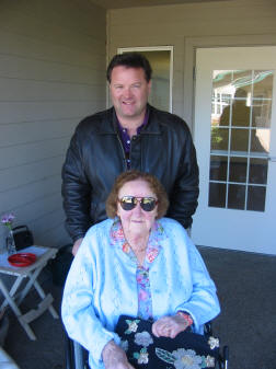
Out at
9, went to visit Eric’s Uncle Bruce and Aunt Karen, wonderful, hospitable
folks with signs on the door inviting folks in for tea and coffee. We
chatted with them (and their cats) for a while, then went to an assisted living
facility to visit Eric’s grandmother. She is almost blind, but could see well
enough to say to Eric “They are feeding you well enough, aren’t they?”
She is in her early 90’s, sharp as a tack and hilarious.
We had lunch with her, and then hit the road at 1 for a short mileage
day. Took 101 along the coast, sea
mist blowing in over the hills, curling over the tops of towering evergreens, a
magical sight. |
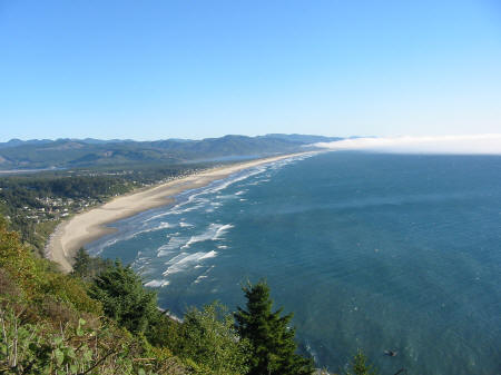
Oregon
had the most beautiful coastal bridges and inlets I have ever seen.
Little harbors full of fishing boats and calm water behind the river
bars. I have got to come back here
again.
Moved inland at
Reedsport on Highways 38 and 138 along the Umpqua River.
The Umpqua is a gorgeous river, running over bedrock that was often
visible under the clear water, in other places breaking the surface to form
islands and shoals. The rock is
crazed and cracked into thousands of intricate, abstract patterns.
I saw a bald eagle swoop down and snag a fish out of the river.
Later we were cruising along, Eric ahead of me and a PT Cruiser in front
of him, when the Cruiser braked suddenly. I
could not see what he was slowing for, there was no place to turn off, but he
was slowing down fast. Then I
spotted it…there was a spike buck on the right-hand shoulder. The Cruiser and Eric got past, and he raised his head and
started to move as I came up on him. I
had bled off most of my speed by then, so I just putted along, and he ran right
beside me for about 100 yards, then crossed the road in front of me and bounded
up the hill into the woods. It was
neat to be able to be so close to him.
A short hop on
I5 brought us to Roseburg, where we found a visitor center and stopped for some
local information. The center was
staffed by a very nice older lady who told us that there was no available
lodging in Crater Lake (our destination), but that there was a nice lodge in
Diamond Lake, about 20 minutes closer. Sounded
nice to us, so we decided to head out. We rode up 138 for 80 some odd miles of wonderful curves
following the river towards Crater Lake. Not
paying attention to my speed, I looked down a few times and found that I was
running right at 100 mph. We took a
room at the lodge, did laundry, and had a dinner of blackened prime rib and a
great bottle of red wine that Eric chose. Short day today, 233 miles.
September 24
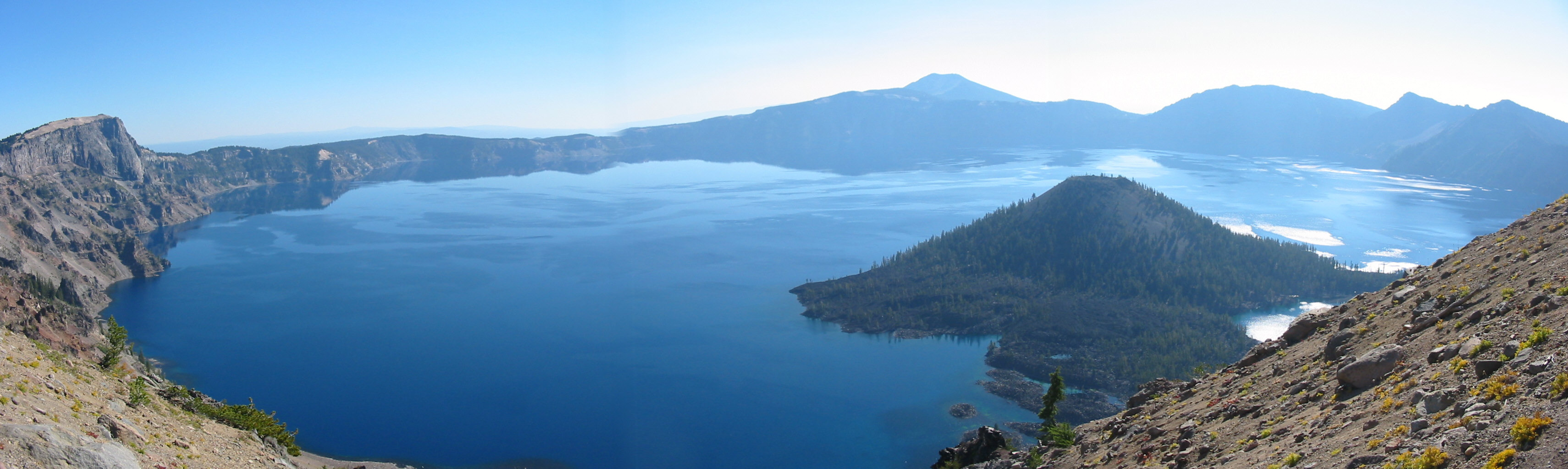
We had a big breakfast
at the lodge served by a sullen waitress, then headed up to Crater Lake, which
was about 20 miles away. The lake
was gorgeous
in the early morning sun, with deep blue water.
We ran around the lake and noticed how warm it was...it had started in
the 50s, but was high 60's already, even at this altitude (7000 ft) and it felt
even warmer. We went to the visitor
center, and as we sat there planning our route, a bike putted up next to mine
and shut down. The rider looked
over at my bike, looked up at me, and said, “Who puked on your bike, aye?” His name was Lefty, he was a Canadian (aye) aircraft mechanic
training in Reno, headed back north. He
was driving a Frankenstein bike…he claimed it had a Shadow motor, a mix of
Shadow and Valkyrie frames, Kawasaki wheels and fenders, and a custom wiring
harness. I liked the John Deere
stickers on the tank. He and Eric
chatted and “aye’ed” as I looked around the visitor center.
When I got back, we poured over the maps and decided that we would head
down to I5 to make some time. I
knew it would be hot and boring, but we wanted to get close to Yosemite today.
We were saddling up when a car from Colorado pulled in behind us.
A guy got out, looked at the bikes, and said:
"Florida
and Alaska"?
“Yeah,
we met in Texas.”
“Where
ya headed?”
“Not sure.”
He
just shook his head and wandered off....
We took a deliciously
twisty road bordered with towering fir trees down towards Medford.
As we approached Medford and the interstate, the skies grew hazy and the
temps rose. It was in the 80s in
Medford. I5, in that area, is
actually quite pretty for an interstate, hilly with mountains all around.
We started climbing and I looked forward to a drop in temps, but it
actually got hotter at the pass! And
even hotter as we descended again. We
stopped in Weed, CA, in the shadow of Mt. Shasta, for gas. As Eric was cleaning
his windshield, his headlight fell out of the headlight bucket...the screws had
vibrated out! Thankfully, there was a Napa store close by, so some screws and
some LocTite were obtained, a repair was made, and there was much rejoicing.
We were back on the road in no time, and as the land flattened out the
temps continued to rise. There was so much haze that we could barely see the outlines
of the mountains to our right. As
we came out of Redding, the temp peaked at 110 degrees! I drank 35 ounces of Gatorade in 45 miles!
We pushed on through Sacramento, and had to scrap around looking for gas
as Eric hit reserve and ran on fumes for a while.
We finally left the interstate and found gas at Walnut Grove, where a
cranky gas pump and a clerk with a heavy Pakistani accent added some interest to
things. We rejoined the interstate and ran a little father south, and
took a Microtel at Lodi. I am not
sure how many miles we put on that day.
September 25
As I write, I am sitting at a picnic
table on the Merced River, with El Capitan looming in the background through the
trees. Yesterday, the 25th, Eric
and I got out around 9, with a plan to head south to Sequoia National Park, come
back up north to Kings Canyon, take a hotel, then do Yosemite on the 26th with
my buddy Jan from Fresno, then spend the night of the 26th with Eric’s
friends, Alex and Kathleen in Mariposa. We
struck out, staying on I5, and met what might have been every straight-piped
cruiser bike in southern California, headed north to a big rally in Reno.
When we pulled off for gas at Lemoore, where we were going to turn east
to Sequoia, Eric had a change of heart. He
really wanted to see a friend in LA. We
discussed options, and decided that we could still see Sequoia and Kings Canyon
that day, spend that night with the Alex and Kathleen, then on the 26th he could
head south to LA while I went to Yosemite.
We could then hook back up in Cedar City Utah in a couple of days to ride
back east. New plan formed, phone
calls made, accommodations arranged, we headed off to Sequoia. I was shocked to see how much drier it was than when I had
been out in April. I remembered
enjoying the ride through the central valley in the spring…the orange blossoms
were out, and every breath was full of their perfume.
But now, in the fall, I found that I did not like the valley…it seemed
dry, dirty, dusty, hot. The lake
coming into the park was really low, and all of the fire danger signs were
"high" or "extreme". Turns
out what I had been calling haze was mostly smoke from forest fires.
We climbed the tight twisty road in Sequoia, which is one of my
favorites, and stopped to take some pictures of the big trees.
Sequoia is one of my favorite parks...a great road, and wonderful
scenery. We pushed on into new territory for me (roads were still
closed for snow when I was out in April) and rode on to Kings Canyon.
The road was not as fun as we progressed, but the scenery was still
spectacular.
We had told Alex and Kathleen that we
would be at their house around 6 for dinner.
It was about 4 when we pulled in to the King’s Canyon Visitor Center
and asked a bored ranger how long it would take to get to Mariposa.
"About 3.5, 4 hours." A
stunned silence. Then Eric said, "We gotta haul ass!"
So we did. We came out on
Hwy 180 (sadly, we did not have time to ride to the dead end of 180 in the
canyon) around long sweepers at well over the posted speed limits.
We only saw 2 LEO’s the whole way, and thankfully we were stuck behind
slower traffic both times. It seemed that the way to make time in this area was
to tuck in behind anyone in a light pickup truck.
We followed a red Mazda running about 80 in 55 zones for a while, then a
Ford Ranger that was whipping around curves at speeds that I was SURE that truck
couldn’t do. I kept expecting to
see him tumble off the road any time.
We made it to Mariposa in 2.5 hours.
Alex and Kathleen live on the top
of a mountain at the end of a gravel road, which has a booby trap made to catch
unwary motorcyclists. It got me!
As I turned up the driveway, I could feel the rear end sink…I gave it
the gas, but too late. So I sat there, stuck, feeling the back end sink lower in the
gravel every time I put power on. Sooner
or later it will sink low enough to sit on the bags, right?
Well, the back tire FINALLY caught something solid, and I got out and
motored up the hill without further ado.
Alex and Kathleen are old friends of
Eric’s. The met many years ago in
Alaska where Alex worked in Eric’s fishing business. They now live in a hay-bale house with solar heat,
solar hot water, a killer view, and two almost-3-year-old twin boys, Liam and
Sydney. The four of them are
wonderful, entertaining hosts, and we stayed up till midnight drinking wine and
talking politics (Kathleen is a liberal and Eric and I are Radical Republicans,
it was a fun night).
I forgot to write down
mileage for the day.
September 26
I awoke to the sound
of prepubescent voices, singing. It
was 5 am, and Liam and Sydney were up. I
catnapped for a while, then got up and had coffee. Kathleen fixed us bagels and
oats, and we were out by around 9...Eric was headed to LA, and
I was headed to Yosemite. Sure
hated to leave, they were really nice people…I hope to see them again
sometime. I successfully negotiated
the motorcycle-eating gravel at the base of the driveway, and waved goodbye to
Eric at the bottom of the hill as I headed north on Hwy 140.
The road snaked along the Merced River, early morning light streaming
into the canyon. I noticed that
there was an old road or railroad bed on the other side of the canyon, and
wondered why they had switched sides when they laid this road.
I felt relaxed and loose as I carved the road, everything falling into
place. There was almost no
traffic...I did pass a guy on a cruiser with a union jack sticker on the back of
his helmet. He was doing what
cruisers do best, cruising. He
melted away in my mirrors.
|
|
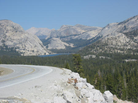
23 miles of twistys brought me to the Arch Rock entrance of Yosemite, for my first visit to this fantastic park. The valley...stunning. The road continued along the river, full of boulders the size of houses that the water danced around. To see El Capitan from the valley floor in the morning light was incredible.
|

|
|
I saddled up and headed for the pass. It was hot by now, and I was looking forward to gaining some elevation and getting cool. Imagine my surprise when I came to a sign that informed me the pass was 45 miles away! I had no idea the park was so big. The road was tight, twisty and steep as it climbed up out the valley, then turned to long sweepers as is continued. Along
the road, my short night’s sleep started to catch up with me. I decided to find a picnic table to stretch out on to take a
nap. I came upon the Porcupine
Flats campground, and turned in. I
approached the campground entrance and slowed to read a sign. I came to a stop and put my foot down, but the ground
wasn’t there…there was a hole on the left side, and I couldn’t reach the
ground. The bike started to fall
left, and when my foot did hit the ground, my knee was not locked and the bike
had momentum...and over it went. Not
hard, it was a slow controlled, fall, but I could not get that left leg straight
to keep the bike from going over. I
got off and lifted the bike back up onto the stand, and there was not a scratch.
Those Honda engineers know how to design crash bars!
I cranked up and found a shaded picnic table, and dozed off for about
half an hour.
|
After I awoke, I
rode to Tioga pass, elevation 9945, then turned around and booked it for Fresno.
Got there about 6:30, where Jan was waiting for me.
Tanya was out with some friends, so Jan and I “batched it”, caught up
on old times, talked religion, politics and business, and had a wonderful
Italian dinner at a local eatery. 220 miles
September 27
I visited for most of
the day with Jan and Tanya and could have stayed longer...they are wonderful
people and great hosts. However, I
wanted to get some miles in so tomorrow would not be such a long day, and so
that I could get an early start crossing the Nevada desert.
The goal was to get across the Sierra Nevada Mountains and close to the
Nevada border. Easier said than
done...there are not many roads that cross the Sierras...it is over 150 miles
between Hwy 120, the east-west route through Yosemite, and J14, the next
east-west road that crosses the mountains to the south.
But I wanted to go north, and cross the mountains on a new (to me) road,
108 over Sonora Pass, north of the park. I
had planned to leave Jan and Tanya’s by 12.
Well, I just couldn't break away, I was enjoying my time with them so
much, and it was 2 by the time I started packing, and 3 by the time I left.
So I decided to backtrack and take 41 back to Yosemite, and 120 to Lee
Vining for the night. There could
be worse things than riding through Yosemite again! I took my time, not blasting around the loafers, enjoying
myself. I was also a little
melancholy...I was headed east now, back home. Part of me was ready, and I knew
that there were still good roads and good times to be had, but pointing the bike
east signaled the beginning of the end. The
time had gone so quickly…
The ride through
Yosemite was uneventful, and I did take solace in the fact that I would be able
to get some pictures at vantage points that I had blown past yesterday.
Alas, the wind had shifted and the valley was pretty smoky from the
fires. It got cool up at the pass,
in the upper 50s, and I was in summer gear, so I was happy to see a steep decent
as I ran through the gate into virgin territory and towards a warm valley.
I entered Lee Vining just as the sun went down, got some fuel, and
cruised the strip. Every hotel in
town was full, all 4 of them. The
RV Park had room, and I cursed myself for sending my tent back home with Lana.
I considered sleeping uncovered in my sleeping bag, but decided against
it. I found the Chamber of Commerce
and went in to inquire about hotels to the south.
An English couple had the only counter girl tied up, and there was
another guy ahead of me. However, I
eavesdropped…Brits were looking for lodging, too.
I walked up behind them and said "What about Bishop?"
"Plenty of hotels in Bishop".
That was all I needed to hear. I
went to the bike, switched from my tinted visor to the clear one, and rode south
into the gathering gloom. Bishop
was only 60 miles away, no problem. But
there was an option that I had not considered.
As I proceeded south, I saw signs for Mammoth Lakes...it was closer, and
I knew there was a ski area there, so there had to be lodging.
It was only 28 miles! Done!
As I turned off the exit and started up the hill to town, I saw a thin
crescent moon that had just risen, hanging over the mountains. Sure
enough, there was lodging, but this was a ski town...the TravelLodge had one
room left, at $100. The Motel 6 had
rooms, at $70...Yikes! Oh, well…
I took a room, made some calls, did some laundry, and hit the sack.
September 28
|
|
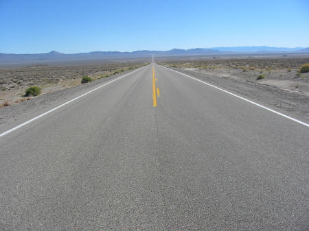
I had a 5 AM wakeup call, which I ignored. Soon I got another wakeup call, in the form of somebody’s car alarm going off in the parking lot...it wailed on for 4-5 minutes, and by that time I was irritated enough to stay awake. I got up, packed, went to a cafe across the street for breakfast, and hit the road. I was REALLY glad that I did not choose to sleep outside last night; it dropped into the mid 30's! Temps had risen to the low 50's as I headed south on 395 to Bishop then northeast on 6. There is no direct route across Nevada in this area, so I had to zigzag across the state, like a sailboat tacking into the wind. The country was beautiful in a stark, barren kind of way, brown ranges of mountains running roughly north-south, with big valleys in between. The road generally ran straight across those valleys, and I could sometimes see a ribbon of road stretching 20-30 miles in front of me. There were areas where the only sign of humanity was the road...no signs, no cars, no houses, no fences, not even contrails in the sky. |
I gassed up in Tonopah,
a town that looked like it was trying to come back…there were some new stores
and shops, but a lot of boarded-up buildings as well.
From there I continued on 6 to 375, the Extraterrestrial Highway, down to
93 at Ash Springs. At noon, the
thermometer hit 90, and only went up another 2 degrees after that. I was happy that I had decided to take this northern route
with more elevation...Las Vegas was supposed to be 100 today, which meant that
the southern route through Death Valley would probably be 115-120.
Somewhere out here I began to see Joshua trees.
Speed limit was 70, and there was nobody out on this lonely highway, so I
set the cruise at 80 and kicked back. I
could have cruised at 100 or more, but didn't want to burn too much fuel, since
I was not sure where the next gas was.
Good thing, for two reasons. Just
outside of Caliente, I met a trooper who flashed his lights at me and pointed
down, telling me to slow down. I
waved and backed off; thinking that it was silly to be enforcing speed limits
out here. Second reason...201.5
miles to the next working fuel pump. There
is no way I could have taken this route on my Valkyrie, it just did not have the
range. I got 40 mpg on that tank, and had another 60 miles of gas left...but it
sure was nice to see that station!
I paid $2.39 for
regular.
As I moved on to
Hwy 319, the trees started to appear, short evergreens, and maybe pinion pines.
These were the first big stands of trees I had seen in several hundred
miles! I came in to Cedar City and
took a room at the Comfort Inn and settled in to wait for Eric. There was a guy
on a blue GoldWing 3 doors down, so I went down and spoke.
He was traveling from Huntington Beach, CA, headed to Ogden UT.
He had pulled in for gas and dumped the bike on the exit ramp in some
sand. He had done some cosmetic
damage and scratched his ankle...thankfully he was wearing full gear and a
helmet, because he had bopped his head pretty hard when the bike went down, even
though he was only running about 20 when he hit.
But the bad news...the bike wouldn't start. The reverse light was flashing.
He had pushed (strong guy) the bike to the hotel, taken a room, called
Honda, and started working on the bike, trying to fix the problem so he could
get back on the road without having to wait on a service department on a Sunday.
He thought maybe he had knocked something loose on the right side of the
bike where all the cosmetic damage was. Then
he decided to try to disconnect the reverse button to see if that would solve
the problem. He disassembled the
handlebar control housing, but found that the connections were soldered, and
asked me if I had some wire cutters. I
did, but looked at the connections, and had a bright idea...why not see if he
could disable the reverse switch at the fuse box...I knew that there were
several fuses that controlled the reverse switch, and that would be better than
cutting wires. We pulled off the
body panel and started pulling fuses...sure enough, the first 5 amp fuse, which
controlled the starter and reverse, was blown.
We replaced it and the bike cranked right up.
Boy, were we relieved! He
repacked, said thanks and goodbye, and headed north. Brad from Huntington Beach, I hope you had a good, and safe,
rest of your trip.
443 miles today.